![](/images/other/stat-length.png)
![Trail Walking Le Poujol-sur-Orb - Le Suquet-Crete de Caudière - Photo](https://media.geolcdn.com/t/1900/400/ext.pjpeg?maxdim=2&url=https%3A%2F%2Fstatic1.geolcdn.com%2Fsiteimages%2Fupload%2Ffiles%2F1553511878bg_sport_marche.png)
Le Suquet-Crete de Caudière
jdelettrez
User
![Length](/images/other/stat-length.png)
Length
15.4 km
![Max alt](https://static1.geolcdn.com/siteimages/upload/files/1508320355ic_sort_altitude_max_24dp.png)
Max alt
773 m
![Uphill gradient](https://static1.geolcdn.com/siteimages/upload/files/1508320355ic_sort_den_pos_24dp.png)
Uphill gradient
667 m
![Km-Effort](/images/other/stat-length.png)
Km-Effort
24 km
![Min alt](https://static1.geolcdn.com/siteimages/upload/files/1508320355ic_sort_altitude_min_24dp.png)
Min alt
172 m
![Downhill gradient](https://static1.geolcdn.com/siteimages/upload/files/1508320355ic_sort_den_neg_24dp.png)
Downhill gradient
667 m
![Boucle](https://static1.geolcdn.com/siteimages/upload/files/16400158638029165_repeat_loop_refresh_sync_direction_icon.png)
Boucle
Yes
Creation date :
2014-12-10 00:00:00.0
Updated on :
2014-12-10 00:00:00.0
![Walking](https://static1.geolcdn.com/sitytour/trail-icons/101.png)
5h00
Difficulty : Difficult
![Scan this QR Code to open this trail in the SityTrail application](https://capi.geolives.com/qq0zvz2zws4bq2lad0pu/sitytour/trails/258382/qr.png?size=200)
FREE GPS app for hiking
About
Trail Walking of 15.4 km to be discovered at Occitania, Hérault, Le Poujol-sur-Orb. This trail is proposed by jdelettrez.
Description
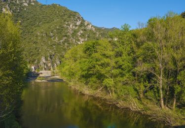
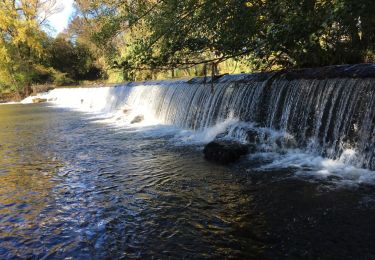
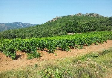
Montée au Écrivains combattant par un sentier en corniche au dessus des gorges de Madale. Descente par les anciennes drailles passant à Combes et Tortaillan. Départ parking voie verte - 6h
Positioning
Country:
France
Region :
Occitania
Department/Province :
Hérault
Municipality :
Le Poujol-sur-Orb
Location:
Unknown
Start:(Dec)
Start:(UTM)
505159 ; 4825426 (31T) N.
Comments
Trails nearby
![Trail Walking Hérépian - herepian pic de Tantajo - Photo](https://media.geolcdn.com/t/375/260/ext.jpg?maxdim=2&url=https%3A%2F%2Fservices.sitytrail.com%2FGeolivesWS%2FDownloadMedia.ashx%3FTrailID%3D656804%26Media%3D20161106140841.jpg)
![Walking Walking](https://static1.geolcdn.com/sitytour/trail-icons/101.png)
herepian pic de Tantajo
Walking
Easy
(1)
Hérépian,
Occitania,
Hérault,
France
![](/images/other/stat-length.png)
13 km | 18.6 km-effort
4h 17min
![](https://static1.geolcdn.com/siteimages/upload/files/16400158638029165_repeat_loop_refresh_sync_direction_icon.png)
Yes
![Trail Walking Colombières-sur-Orb - Colombières sur Orb - Photo](https://media.geolcdn.com/t/375/260/ext.jpg?maxdim=2&url=https%3A%2F%2Fservices.sitytrail.com%2FGeolivesWS%2FDownloadMedia.ashx%3FTrailID%3D350907%26Media%3Dfix__20140914134818.jpg)
![Walking Walking](https://static1.geolcdn.com/sitytour/trail-icons/101.png)
Colombières sur Orb
Walking
Medium
(1)
Colombières-sur-Orb,
Occitania,
Hérault,
France
![](/images/other/stat-length.png)
11.3 km | 20 km-effort
4h 12min
![](https://static1.geolcdn.com/siteimages/upload/files/16400158638029165_repeat_loop_refresh_sync_direction_icon.png)
Yes
![Trail Walking Colombières-sur-Orb - Les gorges de Colombières - Photo](https://media.geolcdn.com/t/375/260/ext.jpg?maxdim=2&url=https%3A%2F%2Fservices.sitytrail.com%2FGeolivesWS%2FDownloadMedia.ashx%3FTrailID%3D335244%26Media%3Dfix__20140805142334.jpg)
![Walking Walking](https://static1.geolcdn.com/sitytour/trail-icons/101.png)
Les gorges de Colombières
Walking
Difficult
(1)
Colombières-sur-Orb,
Occitania,
Hérault,
France
![](/images/other/stat-length.png)
14.9 km | 24 km-effort
6h 33min
![](https://static1.geolcdn.com/siteimages/upload/files/16400158638029165_repeat_loop_refresh_sync_direction_icon.png)
Yes
![Trail Walking Taussac-la-Billière - orgues de taussac - Photo](https://media.geolcdn.com/t/375/260/ext.jpg?maxdim=2&url=https%3A%2F%2Fservices.sitytrail.com%2FGeolivesWS%2FDownloadMedia.ashx%3FTrailID%3D145474%26Media%3D20120811112610.jpeg)
![Walking Walking](https://static1.geolcdn.com/sitytour/trail-icons/101.png)
orgues de taussac
Walking
Easy
(2)
Taussac-la-Billière,
Occitania,
Hérault,
France
![](/images/other/stat-length.png)
9.3 km | 14.2 km-effort
3h 1min
![](https://static1.geolcdn.com/siteimages/upload/files/16400158638029165_repeat_loop_refresh_sync_direction_icon.png)
Yes
![Trail Walking Colombières-sur-Orb - Les gorges de Colombières - retour sentier de la Buffe - Photo](https://media.geolcdn.com/t/375/260/ext.jpg?maxdim=2&url=https%3A%2F%2Fservices.sitytrail.com%2FGeolivesWS%2FDownloadMedia.ashx%3FTrailID%3D129712%26Media%3D13257_6.jpg)
![Walking Walking](https://static1.geolcdn.com/sitytour/trail-icons/101.png)
Les gorges de Colombières - retour sentier de la Buffe
Walking
Difficult
(1)
Colombières-sur-Orb,
Occitania,
Hérault,
France
![](/images/other/stat-length.png)
16.1 km | 30 km-effort
7h 0min
![](https://static1.geolcdn.com/siteimages/upload/files/16400158638029165_repeat_loop_refresh_sync_direction_icon.png)
Yes
![Trail Walking Les Aires - Saint Michel la coquillade - Photo](https://media.geolcdn.com/t/375/260/ext.jpg?maxdim=2&url=https%3A%2F%2Fservices.sitytrail.com%2FGeolivesWS%2FDownloadMedia.ashx%3FTrailID%3D419022%26Media%3Dfix__20150406153326.jpg)
![Walking Walking](https://static1.geolcdn.com/sitytour/trail-icons/101.png)
Saint Michel la coquillade
Walking
Medium
(1)
Les Aires,
Occitania,
Hérault,
France
![](/images/other/stat-length.png)
13.2 km | 21 km-effort
4h 7min
![](https://static1.geolcdn.com/siteimages/upload/files/16400158638029165_repeat_loop_refresh_sync_direction_icon.png)
Yes
![Trail Walking Colombières-sur-Orb - 34 colombier sur orb - Photo](https://media.geolcdn.com/t/375/260/ed1e5c61-79a3-4908-ab1a-6d651ba5ba36.jpg&format=jpg&maxdim=2)
![Walking Walking](https://static1.geolcdn.com/sitytour/trail-icons/101.png)
34 colombier sur orb
Walking
Medium
Colombières-sur-Orb,
Occitania,
Hérault,
France
![](/images/other/stat-length.png)
12 km | 21 km-effort
6h 18min
![](https://static1.geolcdn.com/siteimages/upload/files/16400158638029165_repeat_loop_refresh_sync_direction_icon.png)
No
![Trail On foot Colombières-sur-Orb - GRP Les gorges de Colombières - Photo](https://media.geolcdn.com/t/375/260/41796b95-b1ee-46e7-97f8-cdd9e3a51e62.jpeg&format=jpg&maxdim=2)
![On foot On foot](https://static1.geolcdn.com/sitytour/trail-icons/100.png)
GRP Les gorges de Colombières
On foot
Easy
Colombières-sur-Orb,
Occitania,
Hérault,
France
![](/images/other/stat-length.png)
9.6 km | 18.9 km-effort
4h 18min
![](https://static1.geolcdn.com/siteimages/upload/files/16400158638029165_repeat_loop_refresh_sync_direction_icon.png)
Yes
![Trail On foot Vieussan - La Tour du Pin - Photo](https://media.geolcdn.com/t/375/260/0c5b5418-a009-43dc-b9bb-024360896496.jpeg&format=jpg&maxdim=2)
![On foot On foot](https://static1.geolcdn.com/sitytour/trail-icons/100.png)